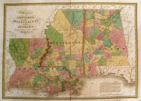
409 Map of Louisiana, Mississippi and Alabama
Map of Louisiana, Mississippi and Alabama, Constructed from the Latest Authorities. Maker: Anthony Finley, 1826, Philadelphia, 22" x 17". Remarkable large format map from Finley's New American Atlas. The map presents an excellent look at the 3 states shortly after their admission into the Union. The northern part of each state is dominated by oversized early counties and regions which were still in the hands of various Indian Tribes, including the Cherokees and Upper Creeks in Alabama and the Choctaw and Chickasaws in Mississippi. General Jackson's Road is shown, as are the Robinson Road and the Old Natchez Road in Mississippi. A number of early Indian Agency's are shown along the various northern roads. A fabulous example of this scarce map. While the map occasionally appears on the market in pocket map form, it is especially desirable in this atlas format, with wide margins and printed on thick paper. Nice fresh vivid colors. A bit of offsetting, as usual, but one of the nicest examples we have seen.